I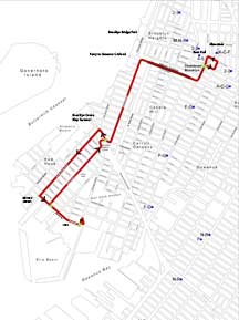
Updated Route Map
(opens as 850kb PDF) |
- New Streetcar Possibilities for Brooklyn – 2013 Presentation (3.3mb PDF)
- STREETCAR BASICS – a brief overview of the benefits of a streetcar system
- Pre-Existing Governmental Approval Documents for the BHRA Streetcar Project.
- Other Materials from Prior Plans / Studies for Brooklyn Streetcar Lines
- NEIGHBORHOOD BENEFITS OF A STREETCAR LINE: (excerpts from the book: Seven Rules for Sustainable Communities Design Strategies for the Post- Carbon World (2010)
- The Basic Principals of Transit Oriented Development
- Charts & Data on Environmental and Economic Advantages of a Streetcar line (vs. other transit modes)
- Streetcar Vs. City Bus Cost Comparison (Includes Official FTA 2007 Operating Ratios spreadsheet) (PDF)
- Streetcar Vs. Bus Rapid Transit (BRT) – results of an award winning DC streetcar study
- A 2011 NYC DOT Streetcar Study
|
By popular request, here is the New BHRA Streetcar Proposal.
This route will run from Red Hook to
Downtown Brooklyn via the Atlantic Avenue Tunnel.
Purpose:
Provide quick and convenient rail transit to Brooklyn neighborhood far
from the existing subway / rail transit network: providing service to
Red Hook, Brooklyn Bridge Park and the Brooklyn Cruise Ship Terminal.
Route Location and Design:
The two major changes to the route from the older
maps shown on our “:maps” page (maps created in 2001 and earlier).
Are an extension of the former red hook terminus east towards
areas that have developed since 2001 (such as IKEA), and a bifurcated
route through part of Red Hook. The position of the track
loops, have also changed slightly.
Rationale behind
bifurcating the streetcar route through Red Hook (compared with
a double-track route on Richards St.)
:
1. The “down line” (Van Brunt St.) services the burgeoning commercial
strip, while the “up line” (Richards St.) serves a more residential
area.
2. Van Brunt Street is a little on the narrow and congested side, so
bifurcating the route would help ease vehicular traffic flow.
3. Bifurcating the route is highly cost effective, services the largest
catchment area, with the least amount of track.
4. Increases opportunity for community revitalization (see next section).
Columbia Street, Atlantic Avenue and Boerum Place- are the only streets
that are feasible, given the origin/destination points.
|
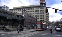
Modern Streetcar in Portland, Or

Vintage and Modern Streetcars Sharing Track in Portland, Or
|
Construction Cost Per Mile:
Again, as per the Portland, Or. model, construction cost is $12
million/mile. Our own “Brooklyn method” of track construction is of
exceptional build and design; while actually being less expensive to
build and maintain.
Economic Revitalization:
Again, our economic model is Portland, Or. Their 4 mile streetcar
line, built in a place similar to Red Hook, spurred $3.5 BILLION in
private revitalization investment, through a six block wide corridor,
centered along the streetcar route. Portland has become a model
“affordable,” modern and efficient
streetcar system, they are currently expanding their system and other
American cities (such as Tucson, Az) have modeled their new urban rail
transit system after Portland’s streetcar system.
Environmental Benefits:
As previously stated, anything that runs on rails, only requires 5% the
energy of anything that runs on rubber tires. Specifically, to move a 1
Ton load of passengers on a bus, requires 30 f.lbs of force. To move
the same 1 Ton weight of passengers on a streetcar, only requires 1-1/4
(1.25) f lbs of force. Click here for more detailed efficiency calculations
Furthermore, non-polluting electric streetcars have numerous other environmental benefits over other forms of transit. See this page for details. |
|
|
|
STREETCAR BASICS – a brief overview of the benefits of a streetcar system
Modern streetcars (like those used in Portland) are
an evolution of the “PCC” type streetcar that was designed in Brooklyn in the 1930s,
to meet Brooklyn traffic conditions and street layout. Streetcars differ
from conventional “light rail” in many ways; such as: streetcars are
designed to stop and accelerate quickly, they are designed to operate
quietly and they can be constructed quickly with minimum excavation,
see more details in the bullets below:
|
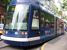
Modern PCC Spec. Streetcar (Portland, OR) |
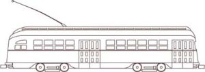
Vintage PCC Streetcar
(still used for transit service in San Francisco, CA and Philadelphia, PA)
|
Passenger boarding area, Simplified track design and unobtrusive overhead wires
(Portland, OR)
The Portland Streetcar has proven so popular that they have ordered additional streetcars and are currently constructing an
extension to the Streetcar route.
Above 3 pictures taken by Brian Kassel on a recent trip to Portland, OR
|
- The Streetcar can operate in mixed traffic with othervehicles, pedestrians and bicycles. The Streetcar does not require
dedicated traffic lanes, and can easily keep up with
traffic. The use of
Passenger Boarding Islands eliminates traffic delays due
to alighting passenger.
- Streetcars
uses a simplified form of overhead wire construction, the cost of which
is only a fraction of conventional light rail catenary wires. Since
Streetcar wires are simplified, the visual impacts of the wires are
greatly mitigated over conventional light rail wires.
- Because Streetcars can operate in existing city streets,its rails are flush with the roadway and its turning radii
fits into existing street geometries, Streetcars will not
divide neighborhoods by presenting physical or psychological
barriers, as do both conventional light rail and divided
highways.
- Because of Streetcars low weight and unique electrical
propulsion package, the Streetcar uses only uses a fraction of the
electrical power requirement of a conventional light rail
vehicle. In fact, the Streetcar spends most of its time coasting
and applying brakes. Streetcars do not require the same large
scale and costly power substations as do conventional light
rail vehicles.
|
|
|
Pre-Existing Design and Governmental Approval Documents, 1996- 2001, Pertaining to the Red Hook To Boro Hall Streetcar Project.
Our updated plans for a streetcar line from Red Hook
to Downtown Brooklyn are an extension of a previously approved project,
rather than an entirely new undertaking. Below are links to 2 PDF
files (each file contains the documents listed below that hyperlink).
Part 1 of 2 Red Hook to Borough Hall Subway Nexus: Project Description, Specifications, Circa 2001 – 3.8mb PDF file includes the following documents:
– Service Description (2 pgs)
– Design Approval Document- (SDOT), May 1, 2001. (Contains much detailed project design information, public hearing dates, various governmental actions, project history, etc. (7 pgs))
– Project Construction And Operation Plans We Used To Obtain ULURP, CEQR and all other approvals (7 pgs)
– Construction Methodology We Used
– Streetcar and Line Operating Characteristics (5 pgs)
NOTE: to maximize public safety, the operating characteristics,
especially acceleration and braking, of any newly built Brooklyn
streetcars, must meet or exceed those of the classic PCC streetcar.
Part 2 of 2 Pre- Existing Governmental Approvals for a Street Running Streetcar Operation in Red Hook Circa 1996- 2001 – 3mb PDF file includes the following documents:
– Letter From CDOT to SDOT, regarding project local match, funding, etc., June 19, 1996
– City Planning (ULURP) Land Use Review Process Requirement Letter Aug 15, 1996
– NYS Dept of State- Coastal Zone Management Approval, Sept 9, 1996
– Project Notice To Proceed, Letter from SDOT to CDOT, Dec 19, 1996
– Contract Award Letter from CDOT to BHRA, June 6, 1997
– City Planning (ULURP) Application, Dec 29, 1997
– Fire Department Approval (FDNY), May 27, 1999 (2 pgs)
– CEQR- Negative Declaration (No Environmental Impact), June 14, 1999 (2 pgs)
– Division of Highway Design Approval (CDOT), June 19, 1999 (same Plans as in Part 1)
– City Planning Commission (ULURP) Land Use Approval, Oct 20, 1999, Calendar # 3, C980267GFK (see Part 1, Design Approval Document)
– Sewer & Water Dept (NYC DEP) Approval, Feb 10, 2000
– Consent Agreement- CDOT, to Construct, Maintain and Operate the Red Hook Streetcar along six streets, Oct 17, 2000.
– OCMC- (CDOT) Approval (Joe Noto, etc), Oct 24, 2000
– NEPA- (SDOT) Categorical Exclusion Determination, May 1, 2001
– SEQR- (SDOT) Determination, May 1, 2001 (2 pgs)
– NYS DOT- Design Approval (PS&E), May 2, 2001 |
|
|
| Other Materials from Prior Plans / Studies for Brooklyn Streetcar Lines
Attached as JPG files, are “example templates”- two pre- engineering drawings I scanned from the circa 1985 Brooklyn streetcar study by Urbitran, and STV. The first drawing, gives the diagrammatic plan for a new streetcar terminus at Atlantic Terminal, with provisions for an extension to Grand Army Plaza, via Vanderbilt Ave.
The second drawing, shows the diagrammatic plan for the streetcar turn from Ft. Green Pl. to Fulton Street. Note this drawing shows in detail, the proper use of a “passenger boarding island” which they refer to as “Platforms”.
Also attached as a PDF file, is the Cover from a Brooklyn Streetcar planning document (PDF),
which I compiled and expanded upon back in 1989. If you can find a copy of it, this document contains, among many other things, street by street pre- engineering plans for all of the proposed Brooklyn streetcar routes. Let me know if you cant find it. The numbers on the Cover, reference ULURP and CEQR applications.
I’m hoping that URS will provide a similar set of drawings as part of their feasibility study. |
| BENEFITS OF A STREETCAR LINE: Land Use, Community Coherence & Economic Revitalization.
The following are selections from the book: Seven Rules for Sustainable Communities Design Strategies for the Post- Carbon World, by Patrick M. Condon, 2010:
SEVEN RULES FOR SUSTAINABLE, LOW-CARBON COMMUNITIES – Rule # 1: RESTORE THE STREETCAR CITY
The North American city was and is a streetcar city. Streetcar cities are characterized by easy access to transit, a wide variety of house types, and services and job sites very close at hand—the exact elements
of a sustainable city. We have largely ignored this fact. It needs rediscovering. (pg 14)
THE STREETCAR CITY AS A UNIFYING PRINCIPLE
The streetcar city principle is not about the streetcar itself, it is
about the system of which that the streetcar is a part. It is about the
sustainable relationship between land use, walking, and transportation
that streetcar cities embody. The streetcar city principle combines at
least four of the design rules discussed in the following chapters: (1)
an interconnected street system, (2) a diversity of housing types, (3)
a five-minute walking distance to commercial services and transit, and
(4) good jobs close to affordable homes. For this reason, it is
offered as the first of the rules and as a “meta rule” for sustainable,
low-carbon community development. (pg 20)
CONTINUOUS LINEAR CORRIDORS, NOT STAND-ALONE NODES
Linear public space is the defining social and spatial characteristic
of the streetcar city This obvious fact has been ignored at best and
derided at worst. Most planning, urban design, and economic development
experts favor strategies that ignore corridors in favor of discrete
and identifiable places, key urban “nodes” in planning terms. Their
plans focus most often on an identified “downtown” or a key
transportation locus, while the thousands of miles of
early-twentieth-century streetcar arterials are either allowed to
languish or blithely sacrificed for parking lots. Yet, very few of us
live within walking distance of a “node,” whereas most of us live
within a reasonable walk of a corridor, however gruesome it may now be.
(pg 25)
Getting people onto transit will not help defeat global warming unless we can find a way to
radically decrease the average daily demand for motorized travel of any
kind and the per-mile GHG consequences of each trip. Community
districts that are complete and that favor short trips over long ones
seem an obvious part of the solution. Inexpensive short-haul zero
carbon transit vehicles, such as trolley buses and especially
streetcars, are a likely feature of a low-energy, low-travel demand
solution. (pg 30)
Precious few cities seem to “get it” in this respect. Portland, again,
is the exception. Portland is the only U.S city to have made a serious
effort to restore its streetcar system. The results could not be more
promising. Jobs, housing, and new commercial services are flocking to
the line, making the community that much more complete and thus
incrementally reducing aggregate per capita trip demand. In Portland,
jobs, housing, clubs, and commercial services are coming closer
together A ten-minute ride on the Portland streetcar gets you where you
want to go. Its speed between these points is irrelevant.
STREETCAR AS AN URBAN INVESTMENT
Most discussions of streetcar focus solely on transit issues, but the
implications are much wider. Streetcars stimulate investment and buses
don’t. This has been powerfully demonstrated in Portland, where the
introduction of a modern streetcar line spurred the high-density
development that helped the City of Portland recoup construction
costs through significantly increased tax revenues. Between 1997 and
2005, the density of development immediately adjacent to the new
streetcar line increased dramatically. Within two blocks of the
streetcar line, $2.28 billion was invested [Editor’s Note: a total of
$3.5 billion through a six block wide corridor centered along the
streetcar tracks], representing over 7,200 [ibid 10,212] new
residential units and 4.6 million [ibid 5.5 million] square feet of
additional commercial [office, institutional, retail, hotel] space;
even more impressive, new development within only one block of the
streetcar line accounted for 55 percent of all new development within
the city’s core. To put this in perspective, prior to construction of
the new streetcar line, land located within one block of the proposed
route captured only 19 percent of all development. (Pg 33)
Most attribute this impressive increase in investment to the presence
of the streetcar line. Developers for the new South Waterfront
development at the other end of the downtown from the Pearl District
would not proceed before the city guaranteed to extend the streetcar
line to the site. These developers, the same ones who had created the
highly successful streetcar serving Pearl District, knew from
experience how important the streetcar is to success. If the free
market tells us anything at all in this case, it is that the economics
of the streetcar, when the value of new investment is included, is much
more cost effective than an investment in rubber-wheeled diesel buses
or heavy transit. (Pg 34) |
|
The Basic Principals of Transit Oriented Development
Portland’s recent multi billion dollar streetcar line land development experience,
speaks particularly, about a concept known as “Transit Oriented
Development”, or “TOD”. Let’s take a quick look at what “TOD-ness”
means, as well as the “TOD- Index”. For this, we refer to
extracts from: TCRP Report 95, TRB, Chapter 17
Objectives of Transit Oriented Development (excerpts from TCRP Report 95, pg 17-2, 17-3):
TOD projects potentially involve a wider variety of stakeholders than
other development projects, reflecting in part the more extensive
involvement of transit agencies and government funding sources. TOD
stakeholders may have a wide range of complementary or competing
objectives. Travel-related objectives include:
- Increasing the opportunities for residents and workers to meet daily needs by taking transit or walking.
- Attracting new riders to public transit, including so-called “choice” riders—riders who could otherwise choose to drive.
- Shifting the transit station mode of access to be less reliant on park-and-ride and more oriented to walking.
- Reducing the automobile ownership, vehicular traffic,
and associated parking requirements that would otherwise be necessary
to support a similar level of more traditional development.
- Enhancing the environment, through reduced emissions
and energy consumption derived from shifts in commuting, other trip
making, and station access to environmentally friendly travel modes.
Non-transportation objectives may include providing desirable and
affordable housing choices, enhancing sense of community and quality of
life, supporting economic development or revitalization, shifting
development from sensitive areas, minimizing infrastructure costs, and
reducing sprawl.
Clich here for more information on Transit Oriented Development |
|
|
The Environmental and Economic Advantages of a Streetcar line over other transit modes:
As stated in the Seven Rules for Sustainable Communities Design, we have already read (pg 30) that streetcars
have ZERO spot emissions. Furthermore, according to the graph on pg 37 entitled
“Life Cycle Carbon Emissions per Passenger Mile”, the streetcar comes
in at the very lowest carbon lifecycle, of all transportation modes, at
32.59. Note that “Bus Rapid Transit” (BRT) comes in high, at 201.40. This is because the streetcar uses the least possible amount of energy. Note that in NYC, streetcar carbon figures would be even lower, as much of our power is derived from hydro-electric sources, rather than coal.
Next, lets address an obvious question: Why Build A Streetcar line rather than a simple bus?
Many decision makers fall into the trap of thinking of a streetcar line
in terms of “existing ridership justification”, and thereby not
understanding the basic underlying concept of what any railway does- A
properly placed and well designed streetcar line creates its own demand !!
As the General Manager of the San Francisco transit authority “MUNI”
said it back in 2001, “People Who Wouldn’t Ride A Bus Will Ride A
Streetcar”- (Michael T. Burns, quoted in Railway Age, May, 2001, pg 45). This comment was made regarding a San Francisco electric bus line that was converted to the Embarcadero Streetcar (F Line) circa 1995- the ridership instantly DOUBLED! (and ridership has kept increasing to the present !)
As for Capital Costs, according to the graph “Total Capital Cost Per Passenger Mile” (pg 37), the streetcar comes in at a mere 71 cents ($0.71) per Passenger Mile. Note that “Bus Rapid Transit” (BRT) comes in at a hefty $1.12, fully 1.6 times greater than streetcar! |
|
|
Streetcar Vs. Bus Rapid Transit (BRT) – results of an award winning DC streetcar study:
The recent award winning DC streetcar study states
that Bus Rapid Transit (BRT) doesn’t make the cut, The study
determined that the streetcar is far superior in terms of
cost-to-benefit ratio, and local economic development. The D.C.
study determined:
“In terms of taxpayers dollars, the “streetcar offers a better ratio of
benefits to costs compared to Bus Rapid Transit (BRT) or Light Transit.
While BRT is less expensive to implement, it does not generate the real
estate investments to the same degree that streetcars can. While light
rail can produce similar benefits to streetcars, implementation costs
are many times more than that of streetcar.” Further details can be found here. A copy of the study can likely be obtained from the consultant Goody Clancy.
We sincerely hope that NYC DOT and URS, heed this study’s findings. The
new Washington DC streetcar line added $10 Billion- $15 Billion to
their local economy. A great article on the new DC streetcar system can
found here. |
|